Congratulations you have finished the treasure hunt! Click here to add Guatemalan souvenirs to your account!
Stories & Facts
Clue 1
A Brief History of Guatemala
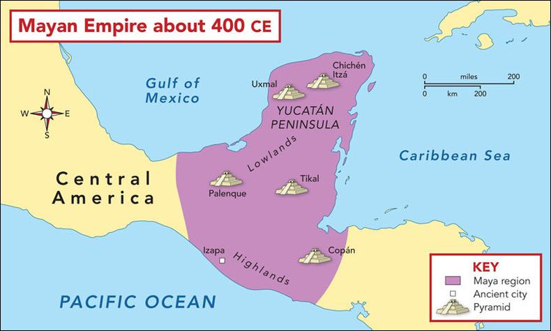
Guatemala was home to the ancient civilisation of the Maya. This was a powerful and advanced civilisation that built many pyramids that we can still visit today. The Maya civilisation was at its height from around 250 AD to 900 AD in what was called the Classic Period and stretched from south eastern Mexico to western Honduras and El Salvador . When the Europeans arrived in the 14th century, the Mayan civilisation was already declining. Spanish conquistador Pedro de Alvarado defeated the Maya in 1524 and the area became a Spanish colony. Due to natural disasters, Guatemala has had three different capital cities. The first was Ciudad Vieja which was destroyed by an earthquake and floods. The second was Antigua, which was also destroyed by earthquakes. The third capital was founded in 1776, Guatemala City.
In 1821, Guatemala gained independence from Spain and became part of the Mexican Empire. Later it became a member of the United Provinces of Central America for a short time.
From 1960 to 1996, Guatemala endured a bloody civil war fought between the US-backed government and leftist rebels, including genocidal massacres of the Maya population perpetrated by the military. Since a United Nations negotiated peace accord, Guatemala has witnessed both economic growth and successful democratic elections, though it continues to struggle with high rates of poverty, crime, drug trade, and instability.
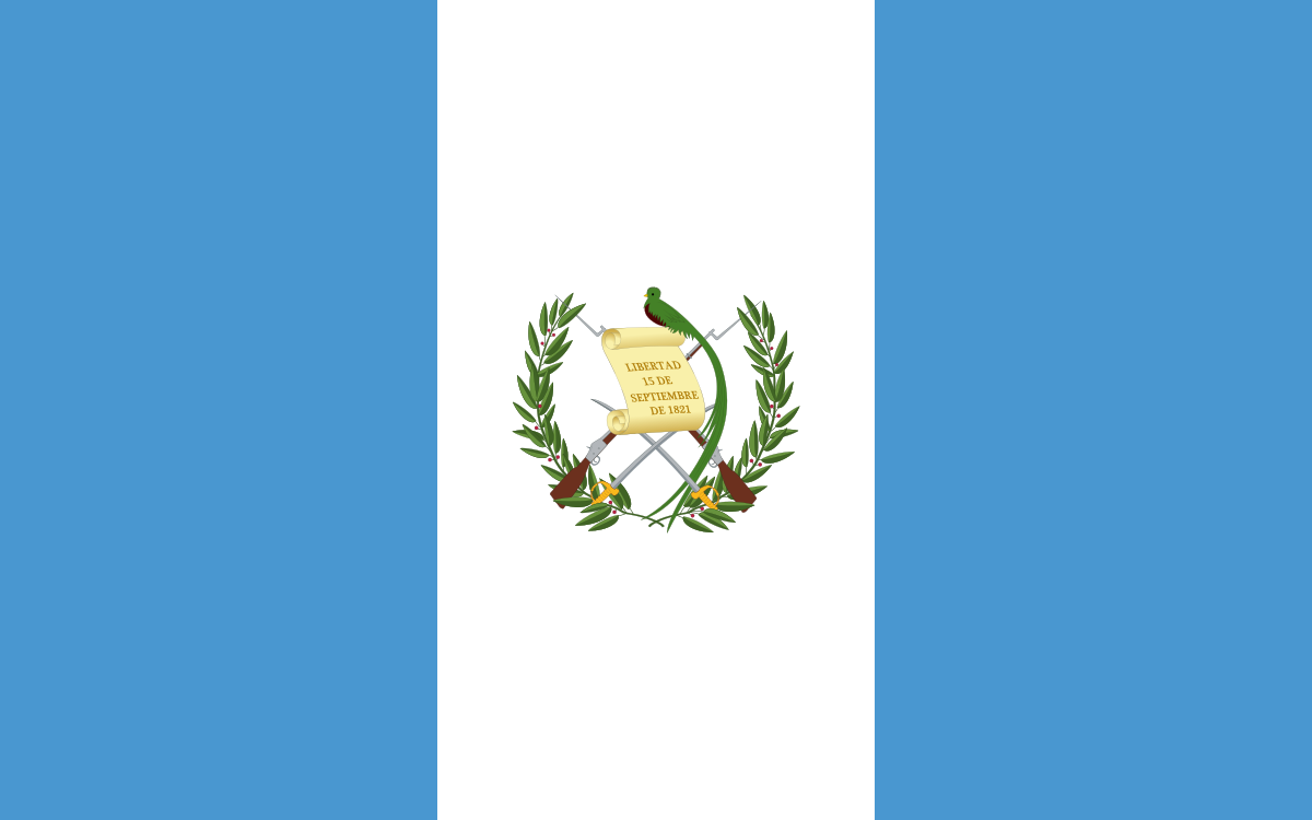
Below - The national flag adopted in 1871. The two sky blue stripes represent the fact that Guatemala is a land located between two oceans and the sky over the country. The white signifies peace and purity. The blue and white colours, like those of several other countries in the region, are based on the flag of the former Federal Republic of Central America (1823 - 1841).
Clue 2
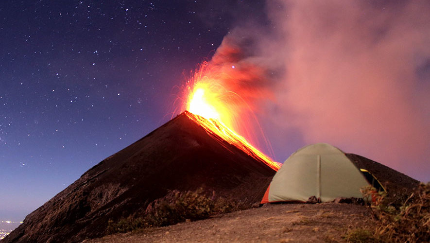
Volcán de Fuego (Spanish for "Volcano of Fire")
Volcán de Fuego is famous for being almost constantly active at a low level. Small gas and ash eruptions occur every 15 to 20 minutes. Its possible to see these up close from the neighbouring Volcan de Acatenango which is popular with tourists - several agencies run overnight camping tours to the peak of this volcano. During the trek up to the 3,976m summit tourists can feel the eruptions and see the smoke bellowing upwards during the day but during the night this dramatically changes to red glowing eruptions of lava throwing bits of molten rock down the volcano's steep slopes.
However larger eruptions do occur most recently in 2018 when a sudden eruption left almost no evacuation time and caused the death of nearly two hundred people (confirmed but actual toll is expected to be much higher). It was the deadliest eruption in Guatemala since 1929.
Below - Camping overnight at Volcán de Fuego.
Clue 3
Antigua Guatemala
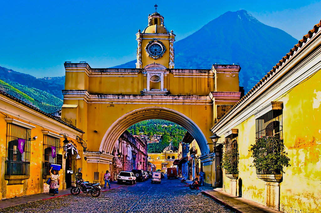
Built 1,530.17m above sea level in an earthquake-prone region, Antigua Guatemala, the capital of the Captaincy-General of Guatemala, was founded in 1524 as Santiago de Guatemala. It was subsequently destroyed by fire caused by an uprising of the indigenous population, re-established in 1527 and entirely buried as a result of earthquakes and an avalanche in 1541. The third location, in the Valley of Panchoy or Pacán, was inaugurated in March 1543 and served for 230 years. It survived natural disasters of floods, volcanic eruptions and other serious tremors until 1773 when the Santa Marta earthquakes destroyed much of the town. At this point, authorities ordered the relocation of the capital to a safer location region, which became Guatemala City, the county’s modern capital. Some residents stayed behind in the original town, however, which became referred to as “La Antigua Guatemala”.
Santa Catalina Arch
This arch was built in 1694 for a specific purpose rather than aesthetics. On either side of the arch are two convents, Within the convents lived cloistered nuns they lived on one side of the of the arch and taught at a school on the other. The nuns had taken vows of seclusion and had to avoid all contact with the outside world; even being seen in public was off-limits. While attempts had been made to find a school property that bordered the convent, the religious order had no luck and the nuns found themselves in a predicament. They needed to teach, but could hardly just walk out the door onto the bustling street and cross it with the public. In order for the nuns to go incognito, the idea of a footbridge was proposed, and Santa Catalina Arch was built to join the school and the convent. Within the arch is a hidden passageway enabling the nuns to cross the street without being seen—something you would never guess if you stood below it.
Below - Santa Catalina Arch which hides a secret passageway for nuns.
Clue 4
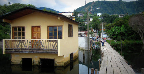
Lake Atitlán and the mystery of the rising water.
The water levels of the lake have been rising leaving submerged and half-submerged buildings dotting the shoreline. The dock at San Pedro La Laguna is one of the best places to see how the lake has been rising (below), with a whole row of houses and shops visible under the water as you step off the boat.
Scientific research in the area is very limited, and most of the explanations are only theories at this stage. The explanation of the local Mayan communities is that the water level at Lake Atitlan rises and falls in a cyclical pattern of around 50 years. According to the elders, this has been the case for as long as people have a collective memory.
Guatemalans and foreigners alike who bought land near the shore have seen expensive investments swallowed up by the lake in recent decades, only now realising why the indigenous Mayan communities build their houses far from the water’s edge.
Below - sunken houses by the dock at San Pedro La Laguna.
Clue 5
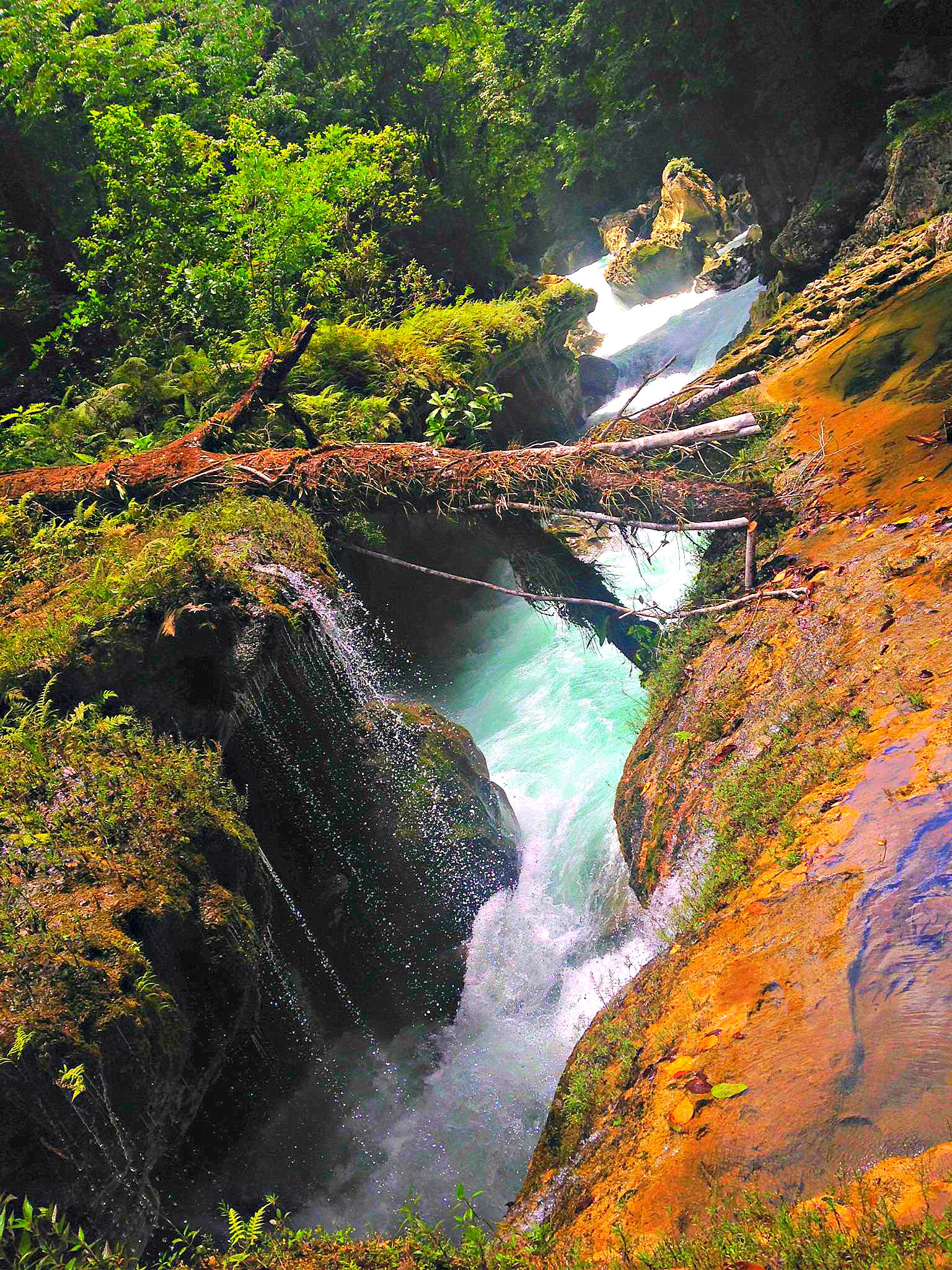
Semuc Champey - meaning 'where the river hides' in Q’eqchi (indigenous language of the Mayan people).
The tiered pools actually exist as part of a 300m long bridge made of limestone deposits that formed over time. Water pools above the bridge, creating tranquil bathing spots, but hidden below all that rock, the Cahabon River flows unseen underneath.
At the far edge of Semuc Champey, some people have disappeared where the river flows underground, never to be seen again.
Below - This is the deadly spot where the Cahabón River disappears underground and flows for 300 meters underneath the limestone bridge and tiered pools that have formed above it.
Clue 6
Castillo de San Felipe del Golfo
The Castillo de San Felipe was built to protect the port of San Antonio de las Bodegas on the south shore of Lake Izabal from frequent pirate attacks, mostly by English pirates. After nightfall, passage along the river into the lake was blocked by a large chain that crossed from the fort to the far bank.
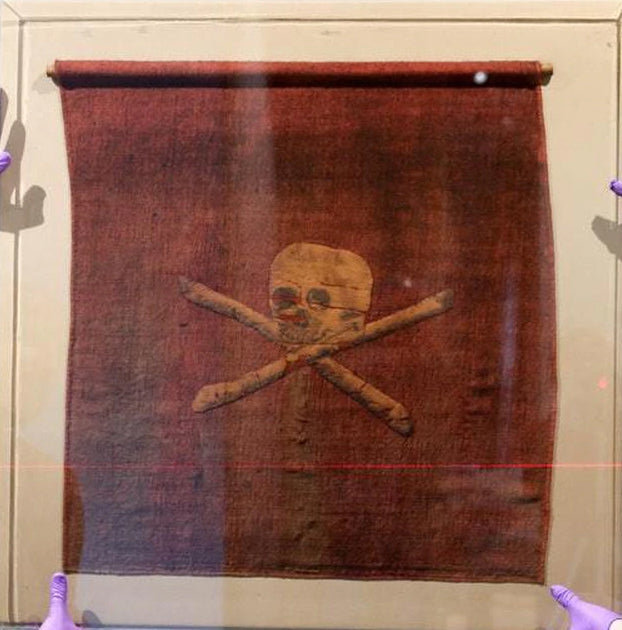
Jolly Roger Pirates Flag
The term “jolly roger,” which now refers to the skull and crossbones flag commonly associated with pirates, is likely derived from the French phrase, “jolie rouge,” meaning pretty red. It was this red flag (not the skull flag) which meant a pirate ship was aggressive and would kill anyone they defeated, paying no heed to the usual rules of engagement.
The black skull and cross bones flag meant the pirates were willing to give you safe quarter. Thus you’d actually want to see a black flag bearing down on you.
Below - A rare 18th Century red Jolly Roger pirate flag. Captured in a battle off the coast of North Africa in 1780 and is on public display in Portsmouth Historic Dockyard UK.
Clue 7
Jaguars - revered by the Mayans and good swimmers.
Jaguars have been revered by ancient cultures throughout the Americas, such as the Aztecs, Mayans and Moche. Ancient cities and buildings in these cultures often had statues, artwork and ceramics that featured jaguars prominently as you will find out in the next clue.
Jaguars are among the few wild cats that like to swim! Some have even been observed swimming across the Panama Canal.
Tikal Facts
The capital of the Mayan Empire
Tikal was the heart of the Mayan empire and ruled most of Mesoamerica (historical region & cultural area stretching from central Mexico to northern Costa Rica) politically, economically and militarily. By 600 AD it had a population of 100,000 with a sports stadium, a school and a hospital. It also had a library packed with thousands of books. Today only four Mayan books still exist.
Filming
Tikal was used as a model for Mel Gibson’s Mayan epic film Apocalypto. However, the film was set during the arrival of the Spanish conquistadors – in the 1500s – at which time cities like Tikal no longer existed.
George Lucas used Tikal as a filming location for the fictional planetary moon of Yavin IV in Star Wars a New Hope.
James Bonds Moonraker used Tikal as the exterior of villain Drax's pyramid headquarters in the Amazon rain forest.
Human Sacrifice
Ritual human sacrifice was practiced by the Mayans, and documentation of sacrifice has been found at Tikal. Sacrifice with bow and arrow is depicted with graffiti upon the walls of Tikal Temple II; another structure depicts a human sacrifice bound to a stake being disembowelled.
The End
After existing for over a thousand years, by 900 AD Tikal had been abandoned. How such a large settlement thrived for so long yet suddenly became undone has been the topic of debate for many years, and even today we don’t know for certain what caused Tikal’s demise. However, most researchers put it at least partly down to drought and deforestation. This coincided with the demise of the Mayan Empire, slowly their major cities were abandoned one by one around this time.
Read up about the modern discovery of Tikal on the next page.
Below - A map of the Mayan Empire which stretched across south eastern Mexico to western Honduras and El Salvador.
Clue 8
In 1525, the Spanish conquistador Hernán Cortés passed within a few kilometres of the ruins of Tikal but did not mention them in his letters. After Spanish friar Andrés de Avendaño became lost in the Petén forests in early 1696 he described a ruin that may well have been Tikal.
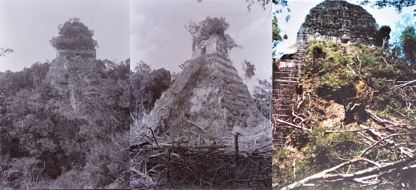
As is often the case with huge ancient ruins, knowledge of the site was never completely lost in the region. It seems that local people never forgot about Tikal and they guided Guatemalan expeditions to the ruins in the 1850s. Some second- or third-hand accounts of Tikal appeared in print starting in the 17th century, continuing through the writings of John Lloyd Stephens in the early 19th century, he heard rumours of a lost city, with white building tops towering above the jungle, during their 1839-40 travels in the region). Because of the site's remoteness from modern towns, however, no explorers visited Tikal until Modesto Méndez and Ambrosio Tut, respectively the commissioner and the governor of Petén, visited it in 1848. Artist Eusebio Lara accompanied them and their account was published in Germany in 1853. Several other expeditions came to further investigate, map, and photograph Tikal in the 19th century and the early 20th century. Pioneering archaeologists started to clear, map and record the ruins in the 1880s.
In 1951, a small airstrip was built at the ruins, which previously could only be reached by several days' travel through the jungle on foot or mule. In 1956 the Tikal project began to map the city on a scale not previously seen in the Maya area. From 1956 through 1970, major archaeological excavations were carried out by the. The Tikal Project recorded over 200 monuments at the site. In 1979, the Guatemalan government began a further archeological project at Tikal, which continued through to 1984.
Below - the temples of Tikal as they are rediscovered from the jungle.