Clue 1 Answers
Answers are written in red.
Remember this treasure hunt is played using Google Earth and not Google Maps.
Welcome to the Southern California Wanderlust Treasure Hunt!
Read the quick timeline of the history of California below and then move onto question 1.
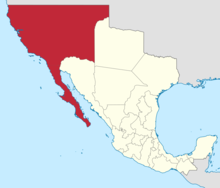
Did you know California is actually split into 3 areas?
Originally known as 'Las Californias' (The Californias) it referred to the vast northwestern region of Spanish America:
1804
The area which was a part of New Spain (the territorial entity of the Spanish Empire consisting of its conquests in the Americas, Asia and Oceania) was split off into a separate province.
1822
Following the Mexican War of independence (1808 - 1821) the area comes under Mexican control and was split into 2 areas - Alta California (Upper California) and Baja California (Lower California).
1848
After the Mexican-American War (1846 - 1848). Alta California (Upper California) was ceded from Mexico to the United States.
Did you know - why the California flag has the words republic on it when its a state?
It's from this period that the modern day state flag originates. In 1846 just before the war there was an attempt by 33 rebels to break away from Mexican rule. The name "California Republic" appeared on their flag indicating their aspiration of forming a republican government.

1850
The populated coastal region of Alta California is admitted into the Union as the State of California. Whilst the vast, sparsely populated interior regions would only later gain statehood as Nevada, Utah, Wyoming, Colorado, New Mexico and parts of Arizona.
1974
The southern region of Baja California becomes Baja California Sur (South Lower California) the 31st state of the 32 Mexican states.
Thus the 3 areas of California - The U.S state of California and the Mexican states of Baja California and Baja California Sur.
1.
To begin the hunt, on Google Earth find the spot which marks the westernmost boundary of the split of Las California's that occurred in 1848 and 1850. Hint - this will be indicated by a fence.
This is the south western corner of the State of California
Do this by:
- Loading up Google Earth.
- Identifying the area of the world you need to go to.
- Move your view so it's above this spot - if you don't know how to use Google Earth then read below, if you do then move on on to question 2.
If you are new to Google Earth this is how to look around photos and the map:
If you are using a PC:
- Zoom in and out using the + & - buttons or quickly using the scroll wheel on a mouse.
- Move around by clicking down, holding + moving.
- Spin your view by holding down shift + moving or by holding down the mouse scroll wheel and moving.
If you are using a touch screen:
- Zoom in and out using 2 fingers in a pinching motion.
- Move around using a finger.
- Spin your view using 2 fingers in a rotating motion.
2.
- At this spot zoom in so you are 150m in height above the boundary.
- Set the height by zooming in and out as instructed above and stopping at the correct height as shown below:

-
Switch into 3D mode by clicking once on the
 button in the corner.
- Once in 3D mode your screen will slowly spin around this location.
- Start exploring this area moving around, zooming in and out and spinning your view.
- Spin your view by holding down shift + moving or by holding down the mouse scroll wheel and moving.
- Spin your view using 2 fingers in a rotating motion.
- In this area look for a small triangular monument pointing upwards that is surrounded by 5 triangles on the floor arranged in a semi circle.
- Tip - you won't need to look further than the stadium (known as the Bullring by the Sea this 21,000 capacity venue is used for bullfighting, the fights were broadcast in Spanish in Los Angeles in the 1960s).
- Stop at this triangular monument.
What is the number of this Monument?
Did you know - the history of the southwestern marker of the US border?
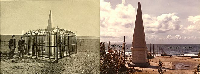
This monument marks the southwestern corner of the Continental United States. The boundary marker was first established as a cairn of rocks in 1849 following the signing of the Treaty of Guadalupe Hidalgo at the end of the Mexican - American War. In 1894 it was found that the initial monument had become so mutilated by visitors that its outlines were nearly destroyed, and its inscriptions partly obliterated. Thus it was repaired and protected with an enclosure as seen below which is the left picture from the 1890s. On the right is the marker in the 1970s.
3.
- Keeping in 3D mode.
- Follow the path north behind the monument heading into the United States. Check with direction you are going by using the compass
 located in the corner (the red end always points to north).
 - Notice this path goes on the west side of an oval shaped park.
- Check you are in the right spot by entering the name of this park below:
- Stop here.
- Switch to street view by clicking once on the man icon
 (located in the bottom right corner).
- This brings up a series of blue lines (routes you can virtually walk down) and small blue circles (pictures you can view).
- Spot in the middle of this park the green marker with a white tree inside.
- Zoom in and out on this marker until a light blue circle appears at this base point.
- Click on this blue circle and it will take you inside a photo.
- Check you are in the right photo by spinning around (use the same techniques as for moving around Google Earth inside the photo) and spotting the man in a white t-shirt, white hat and pushing a pram.
- If you can't see this then you are in the wrong photo, please exit the photo by clicking on the arrow in the top left corner and try the previous steps until you arrive in the correct photo.
Did you know - What the people in this photo are doing?
This park named International Friendship Park is used to allow residents of both Mexico and the United States to meet each other. Throughout its history the amount contact allowed has varied, currently residents of Mexico are allowed up to their side of the fence 24/7 but residents of USA are only allowed to their side of the fence at certain times which is strictly controlled by U.S Border Patrol.
You will notice in the picture a few figures standing at the fence, they are conversing with others on the southern side, the fence only allows for touching of finger tips.
4.
- Below are 2 photos each of part of an object within this picture.
- Look around this photo and identify which 2 objects they are of.
- Tip - spin all around the photo and zoom in on any suspect objects, look carefully! Use the same techniques as for moving around Google Earth inside the photo.
Object 1 (this is a zoomed in part of this object).


- Once you have found them both look at the view between them. What is the man made object which can be seen in this view? Use this one word answer as the password to access the next clue.
Fence

